India
About:
India is one of the oldest civilizations in the world with a kaleidoscopic variety and rich cultural heritage. It has achieved all-round socio-economic progress during the last 65 years of its Independence. India has become self-sufficient in agricultural production and is now one of the top industrialized countries in the world and one of the few nations to have gone into outer space to conquer nature for the benefit of the people. It covers an area of 32,87,263 sq. km, extending from the snow-covered Himalayan heights to the tropical rain forests of the south. As the 7th largest country in the world, India stands apart from the rest of Asia, marked off as it is by mountains and the sea, which give the country a distinct geographical entity. Bounded by the Great Himalayas in the north, it stretches southwards and at the Tropic of Cancer, tapers off into the Indian Ocean between the Bay of Bengal on the east and the Arabian Sea on the west.
Lying entirely in the northern hemisphere, the mainland extends between latitudes 8° 4? and 37° 6? north, longitudes 68° 7? and 97° 25? east and measures about 3,214 km from north to south between the extreme latitudes and about 2,933 km from east to west between the extreme longitudes. It has a land frontier of about 15,200 km. The total length of the coastline of the mainland, Lakshadweep Islands and Andaman & Nicobar Islands is 7,516.6 km.
GEOGRAPHY
Location The Indian peninsula is separated from mainland Asia by the Himalayas. The Country is surrounded by the Bay of Bengal in the east, the Arabian Sea in the west, and the Indian Ocean to the south.
Geographic Coordinates Lying entirely in the Northern Hemisphere, the Country extends between 8° 4? and 37° 6? latitudes north of the Equator, and 68° 7? and 97° 25? longitudes east of it.
Indian Standard Time GMT + 05:30
Area 3.3 Million sq. km
Telephone Country Code +91
Border Countries Afghanistan and Pakistan to the north-west; China, Bhutan and Nepal to the north; Myanmar to the east; and Bangladesh to the east of West Bengal. Sri Lanka is separated from India by a narrow channel of sea, formed by Palk Strait and the Gulf of Mannar.
Coastline 7,516.6 km encompassing the mainland, Lakshadweep Islands, and the Andaman & Nicobar Islands.
Climate The climate of India can broadly be classified as a tropical monsoon one. But, in spite of much of the northern part of India lying beyond the tropical zone, the entire country has a tropical climate marked by relatively high temperatures and dry winters. There are four seasons:
winter (December-February)
summer (March-June)
south-west monsoon season (June-September)
post monsoon season (October-November)
Terrain The mainland comprises of four regions, namely the great mountain zone, plains of the Ganga and the Indus, the desert region, and the southern peninsula.
Natural Resources Coal, iron ore, manganese ore, mica, bauxite, petroleum, titanium ore, chromite, natural gas, magnesite, limestone, arable land, dolomite, barytes, kaolin, gypsum, apatite, phosphorite, steatite, fluorite, etc.
Environment – International Agreements Rio Declaration on environment and development, Cartagena Protocol on biosafety, Kyoto Protocol to the United Nations Framework Convention on climatic change, World Trade Agreement, Helsinki Protocol to LRTAP on the reduction of sulphur emissions of nitrogen oxides or their transboundary fluxes (Nox Protocol), and Geneva Protocol to LRTAP concerning the control of emissions of volatile organic compounds or their transboundary fluxes (VOCs Protocol).
Geography – Note India occupies a major portion of the south Asian subcontinent.
PEOPLE
Population India’s population, as on 1 March 2011 stood at 1,210,193,422 Billion (623.7 million males and 586.4 million females)
Population Growth Rate The average annual exponential growth rate stands at 1.64 per cent during 2001-2011
Birth Rate The Crude Birth rate was 18.3 in 2009
Death Rate The Crude Death rate was 7.3 in 2009
Life Expectancy Rate 65.8 years (Males); 68.1 years (Females) in the period 2006-2011
Sex Ratio 940 according to the 2011 census
Nationality Indian
Ethnic Groups All the five major racial types – Australoid, Mongoloid, Europoid, Caucasian, and Negroid find representation among the people of India.
Religions According to the 2001 census, out of the total population of 1,028 million in the Country, Hindus constituted the majority with 80.5%, Muslims came second at 13.4%, followed by Christians, Sikhs, Buddhists, Jains, and others.
Languages There are 22 different languages that have been recognised by the Constitution of India, of which Hindi is an Official Language. Article 343(3) empowered Parliament to provide by law for continued use of English for official purposes.
Literacy According to the provisional results of the 2011 census, the literacy rate in the Country stands at 74.04 per cent, 82.14% for males and 65.46% for females.
GOVERNMENT
Country Name Republic of India; Bharat Ganrajya
Government Type Sovereign Socialist Democratic Republic with a Parliamentary system of Government.
Capital New Delhi
Administrative Divisions 28 States and 7 Union Territories.
Independence 15th August 1947
Constitution The Constitution of India came into force on 26th January 1950.
Legal System The Constitution of India is the fountain source of the legal system in the Country.
Executive Branch The President of India is the Head of the State, while the Prime Minister is the Head of the Government, and runs office with the support of the Council of Ministers who form the Cabinet Ministry.
Legislative Branch The Indian Legislature comprises of the Lok Sabha (House of the People) and the Rajya Sabha (Council of States) forming both the Houses of the Parliament.
Judicial Branch The Supreme Court of India is the apex body of the Indian legal system, followed by other High Courts and subordinate Courts.
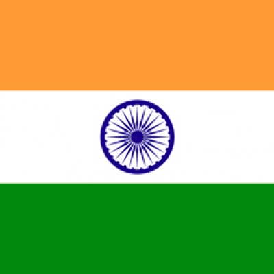
Flag Description The National Flag is a horizontal tricolour of deep saffron (kesaria) at the top, white in the middle, and dark green at the bottom in equal proportion. At the centre of the white band is a navy blue wheel, which is a representation of the Ashoka Chakra at Sarnath.
National Days 26th January (Republic Day)
15th August (Independence Day)
2nd October (Gandhi Jayanti; Mahatma Gandhi’s Birthday)
SOURCE
Source: Ministry of Environment, Planning Commission, Ministry of Health, Press Information Bureau, Census of India, Ministry of External Affairs, Union Budget, Reserve Bank of India.